Regional Differences: The North American Monsoon System
Adapted from: Michael Crimmins. 2006. Arizona and the North American Monsoon System. University of Arizona College of Agriculture and Life Science. Publication No. az1417.
How Does the Monsoon Work?
The official definition for the word “monsoon” is a persistent surface windflow pattern caused by differential heating that shifts direction from one season to another (Greer 1996). The most intensively studied monsoon on Earth is the Indian, or South Asian, monsoon where surface heating of the Tibetan plateau during the summer causes warm, moist air and thunderstorms from the Indian Ocean to stream inland across south Asia. Winds shift direction during the winter as the Indian Ocean is warmer than the continent, bringing an end to the rains. This shift in winds, from onshore to offshore and then back again, happens each year with the changing seasons.
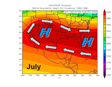
North America has a similar seasonal wind shift that controls summer precipitation in Mexico and the desert Southwest called the North American monsoon system (NAMS). Mid-level winds (~ 10,000 feet) shift from southwesterly to southeasterly as the large Bermuda high-pressure system centered over the east Atlantic expands and builds northwestward across Mexico and into the southwest United States from June into July (Figure 2). Complex interactions between surface heating, topography, and larger-scale circulation patterns modulate the position and strength of the high-pressure system. This shift in circulation transports moisture primarily from the tropical Pacific Ocean up through western Mexico, initiating the summer wet season (Bryson and Lowry 1955, Hales 1974, Carleton 1986, Douglas et al. 1993, Adams and Comrie 1997). There is considerable debate over how much moisture the Gulf of Mexico contributes to monsoon season precipitation due to large mountains in Mexico serving as a barrier to this moisture transport (Hales 1974, Douglas et al. 1993). Modeling experiments have shown that moisture at upper levels (above 10,000 feet) can flow into the southwest United States from the Gulf of Mexico during the summer monsoon season (Schmitz and Mullen 1996).
Figure 1. North and westward expansion of the Bermuda High in mid-levels of the atmosphere. Arrows indicate general flow at ~15,000 feet. (Top) Diagram of the average Bermuda-High during May. (Middle) Diagram of the average Bermuda-High during June. (Bottom) Diagram of the average Bermuda-High during July. (Images provided by the NOAA-CIRES Climate Diagnostics Center, Boulder, Colorado, from their website at http://www.cdc.noaa.gov; arrows added to show general wind flow directions.)
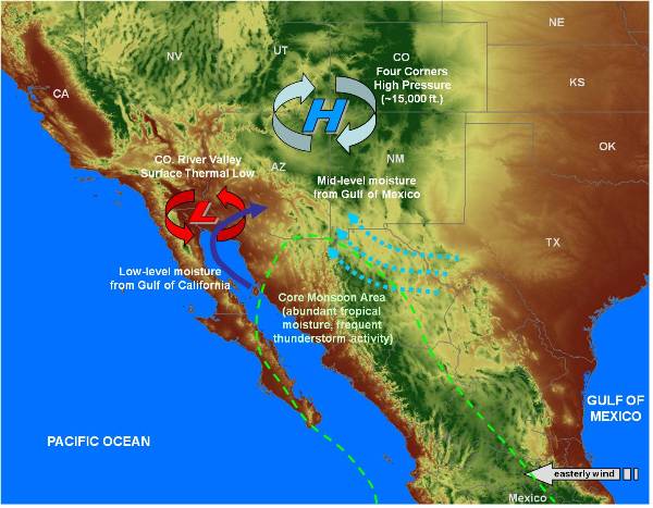
Arizona and New Mexico are on the northern border of the core region of the NAMS. Its location on the northern periphery of this main area of monsoon activity can lead to substantial variability in thunderstorm activity as moisture from the core region advances north or retreats south. Monsoon-related thunderstorm activity across Arizona is primarily tied to the availability of atmospheric moisture. Several regional-scale circulation features can help or hinder the flow of monsoonal moisture into the Southwest (Figure 3). A low-pressure area can develop from the intense surface heating over the Colorado River Valley during the summer and help steer moisture up into the Southwest from the warm, moist waters of the Gulf of California. A mid-level (~15,000 feet) high-pressure system forms over northeastern Arizona (“Four Corners” High) and can help guide mid-level moisture in around the high from the northeast and east that may be in place from thunderstorm activity over the New Mexico or the Rocky Mountains in Colorado. This high-pressure system can also help to move in mid- to upper-level (above ~15,000 feet) moisture from the Gulf of Mexico depending on its geographic position. Southeast Arizona typically will experience a south to southeast flow between these two circulation features, which is ideal for pulling moisture north from the core region of monsoon activity in Mexico. The interplay between the strength and position of these circulation features helps guide the deep moisture into Arizona necessary for monsoon thunderstorm development.
The overall circulation patterns across the southwest United States are very weak during the summer relative to the high- and low-pressure systems associated with the westerly jet stream during the winter. Wind speeds at 10,000 to 20,000 feet in the atmosphere are typically between 10 to 20 miles per hour during the summer versus greater than 50 miles per hour during the winter. When wind flow patterns are weak, monsoon thunderstorms are often unorganized and slow moving. Storms under these conditions can produce large amounts of precipitation in localized areas. Wind flow patterns can strengthen for brief periods during the monsoon and intensify thunderstorm activity. When coupled with upper-level disturbances that increase atmospheric instability, thunderstorms can organize into lines or into much larger individual storms. These types of events can produce widespread heavy rainfall amounts, hail, and damaging winds.
Monsoon activity can also increase in response to deep flows of moisture from the Gulf of California that are initiated by large-scale thunderstorm or tropical storm activity located at the southern end of the gulf. These events are called “gulf surges” and are pressure-induced flows that bring deep moisture into the low deserts of Arizona. Large-scale thunderstorm activity at the southern end of the Gulf of California can produce cool and wet conditions that are drawn up the Gulf toward the Colorado River thermal low-pressure system. Dew point temperatures and winds from the south will often increase dramatically over the lower Colorado River Basin during gulf surge events.
Tropical storm activity in the east Pacific can also directly impact summertime rainfall amounts across Arizona. Tropical storms and hurricanes can trigger gulf surges as discussed above or make landfall in Mexico and continue northeast across the southwest United States bringing heavy and widespread rains. The movement of tropical storm activity across Arizona is infrequent but does occasionally occur later in the summer and into the early fall. Tropical storms possess both copious amounts of moisture and energy and can create widespread flooding events (Smith 1986).
Adapted for eXtension.org by Sabrina Kleinman, University of Arizona
References Cited
Adams, D.K. and A.C. Comrie. 1997. The North American monsoon. Bulletin of the American Meteorological Society. 78: 2197-2213.
Bryson, R.A. and W.P. Lowry. 1955. Synoptic climatology of the Arizona summer precipitation singularity. Bulletin of the American Meteorological Society. 36: 329-339.
Carleton, A.M. 1986. Synoptic-dynamic character of “bursts” and “breaks” in the southwest U.S. summer precipitation singularity. Journal of Climatology. 6: 605-623.
Douglas, M.W, R.A. Maddox, K. Howard, and S. Reyes. 1993. The Mexican monsoon. Journal of Climate. 6: 1665-1677.
Greer, I.W. 1996. Glossary of Weather and Climate. American Meteorological Society: Boston, MA.
Hales, J.E. 1974. Southwestern United States Summer Monsoon Source – Gulf of Mexico or Pacific Ocean? Journal of Applied Meteorology. 13: 331-342.
Schmitz, J.T. and S.L. Mullen. 1996. Water Vapor Transport Associated with the Summertime North American Monsoon as Depicted by ECMWF Analyses. Journal of Climate. 9: 1621-1634.
Smith, W. 1986. The effects of Eastern North Tropical cyclones on the southwestern United States. NOAA Technical Memorandum. NWS WR-197. 229 p.
For More on The North American Monsoon System:
- Climate Change Impacts in the Southwestern U.S.
- Regional Climate Change Impacts from USGCRP
- Regional Climate Models
- Basics of Climate Models


